South Platte Salinity Stakeholder Group

Formed in 2020 out of the recognition that salinity in the South Platte River Basin needs regional dialogue and coordination, the South Platte Salinity Stakeholder Group is a cooperative effort that represents agricultural, municipal, water supply, water treatment, and research interests in the South Platte River and its tributaries from Waterton Canyon to the Colorado/Nebraska state line. Facilitated by the Colorado Water Center, the South Platte Salinity Stakeholder Group works to integrate stakeholder concerns, needs, and priorities to improve our understanding of the sources, loads, trends, and impacts of salinity in the South Platte River Basin.
Salinization in the South Platte Basin
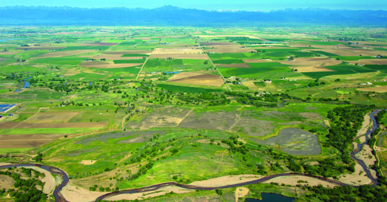
The South Platte River Basin (SPRB) is the most populous and agriculturally productive Basin in Colorado. Approximately 80% of Colorado’s population resides in the SPRB and is expected to increase from 3.5 million in 2008 to 6 million people by 2050. The Basin also has the greatest concentration of irrigated agricultural lands (~ 800,000 acres) that account for approximately 72% of Colorado’s agricultural output. Emerging evidence reveals that the SPRB, like many other intensively developed and irrigated regions worldwide, is experiencing salinization. A recent study of South Platte River salinity revealed that annual average salinity in 2018 was 569 mg/L (Total Dissolved Solids, TDS) in the Denver Metro area (upstream part), increasing to about 700 mg/L from the Metro area to Kersey, CO, and continued to increase to 1,165 mg/L near Julesburg, CO (near the Colorado-Nebraska State line).
The U.S. Environmental Protection Agency has a secondary drinking water standard of 500 mg/L for TDS, which is also the salinity level at which salt sensitive crops like beans, carrots, and onions may experience yield reductions. Many other crops may experience yield reductions in the 1,000 to 2,000 mg/L TDS range (e.g., corn and alfalfa). In addition, treating municipal water with high salinity concentrations can be extremely costly due to the technology and brine disposal required. The consensus among stakeholders and experts is that salinity sources, loads, trends, and potential impacts need to be better understood and addressed in the municipal, agricultural, water-supply, and environmental context of the SPRB.
People
Stakeholders:
|
Aurora Water |
|
Eaton Ditch Company |
|
Brink, Inc. |
|
Lower South Platte Water Conservancy District |
|
Central Colorado Water Conservancy District |
|
Metro Water Recovery |
|
City of Loveland |
|
NEIRBO Hydrogeology |
|
City of Thornton |
|
New Cache Ditch Company |
|
Colorado Ag Water Alliance |
|
North Sterling |
|
Colorado Corn |
|
Natural Resources Conservation Service |
|
Colorado Department of Agriculture |
|
Northern Colorado Water Conservancy District |
|
Colorado Department of Public Health and Environment |
|
Roxborough Water & Sanitation District |
|
Colorado Division of Water Resources |
|
South Metro Water Supply Authority |
|
Colorado Geological Society |
|
St. Vrain Left Hand Water Conservancy District |
|
Colorado State University |
|
USGS Colorado Water Science Center |
|
Colorado Watershed Assembly |
|
Varra Companies |
|
Denver Water |
|
Researchers Involved to Date:


Research
Stakeholder-Informed Research Questions
Stakeholders identified their concerns and needs around salinity in the South Platte River Basin and grouped them into principal themes. The Technical Team, a subgroup of the larger Stakeholder Group, then refined the concerns and needs into research questions. These questions are intended to guide research efforts to ensure relevant and actionable results for the stakeholders. In addition, processes have been established to facilitate technical review of research results as well as ongoing communication and feedback from stakeholders.
- What are the sources of salinity and what are the concentrations/loads in the watershed (Waterton Canyon to the state line): spatial, temporal, amounts, constituents?
1a. Where are the hydrologic inputs and outputs of the watershed?
1b. How does salt accumulate over time and where does it go (load & trends)?
2. What is the interaction of water and land management with sources and concentrations/loads?
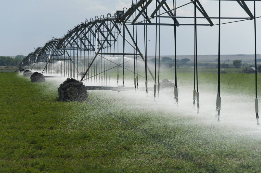
2a. What are the effects of agriculture and irrigation practices on salinity?
2b. What are the effects of municipal and industrial water use & treatment on salinity?
3. What are the impacts of salinity?
3a. Is salinity currently a problem and for whom? (municipal, agriculture, ecosystem (microbiome, aquatic invertebrates))? Where?
3b. Will salinity be a problem in the future and for whom? Where and when?
3c. What are the short-term and long-term salinity implications for species, groundwater, agriculture, municipalities, other states?
4. By source, what are effective mitigation and management strategies to address salinity?
South Platte Salinity Data Dashboard
Current Projects
The South Platte Salinity Stakeholder Group, which represents municipal, industrial, agricultural, and environmental interests, has identified the need for a basin-wide assessment of current salinity conditions. This project aims to summarize the state of knowledge on surface and groundwater salinity in the SPRB. Specific objectives are to (1) assess existing information on the nature and extent of surface and groundwater salinity and its impacts on municipal water supply/treatment and irrigated agriculture in the SPRB; (2) identify key problems and issues caused by rising salinity that are currently affecting representative stakeholders; and (3) organize the collected information into an online portal widely accessible to stakeholders. This will enable planning for targeted applications of monitoring, treatment, and remediation technologies at identified salinity hot spots within the SPRB.
- Farmer Engagement
- Identify farmers and farmland available for long-term salinity characterization – target of 100 monitoring locations
- Farm visits and windshield surveys
- Interviews with producers
- Field observations of soil conditions, pumping wells, and ditches
- Spatial database and evaluation
- Compile data collected during field reconnaissance in spatial database
- Identify long-term monitoring sites
The goal of this project is to initiate a systematic investigation that will lead to a reliable definition of the problem of water and land salinization in Colorado’s South Platte River Basin (SPRB), forming a sound basis for a search for effective solutions. This goal is to be accomplished through the following objectives:
1. Assess existing information on the nature and extent of SPRB salinity and its impacts;
2. Develop a rationale and plan for extensive data collection to enhance the characterization of salinity and its impacts and to support a search for effective solutions; and
3. Initiate the gathering of the required additional data.
Outputs will include (1) established working relationships with stakeholders, experts, and agencies; (2) a written report summarizing available salinity information and laying out plans for a thorough data collection campaign; (3) a SPRB salinity data platform; and (4) an emerging monitoring network and some preliminary collected data.
Information gathered in this project will help water users and managers understand the state of salinity problems in the SPRB and the vulnerability of the agricultural economy to this growing water quality concern. It also will form a springboard for discovery and implementation of effective solutions, leading to diminished land and water salinization and increased crop productivity.
To promote sustainable agricultural practices in Colorado’s South Platte River Basin (SPRB), it is imperative to understand the soil salinity status and its relationship with water resources salinity and other influencing factors. In this research project, we plan to use Landsat 5, 7 and 8 multispectral images to map estimated actual crop evapotranspiration, crop water stress, crop yield, and soil salinity levels (electric conductivity, dS/m) across the SPRB over a historic period of 20 years. The information gained from these maps will aid in the identification of agricultural lands with different levels of salinity impact. We will focus mainly on corn and alfalfa fields because of their large extent in the SPRB and because of their deep root systems and response to salinity. Data on factors potentially contributing to salinity (irrigation methods, agronomic practices, soil types, irrigation water salinity, and geology) will be garnered from existing publications and on-going surveys being carried out by related projects. The information obtained from maps and the datasets shared by these collaborators will be merged into a Geographic Information System (GIS) to explore potential cause and effect relationships. The elaboration of the different salinity maps and apparent rates of salinization will assist in identifying key locations within the SPRB for more detailed monitoring in future projects. Thus, the outcomes of this project will help define a long-term research effort and publications will be a channel to educate stakeholders on the status of agricultural land salinization, its likely causes, and prospects for mitigation.
Resources
Title | Resource Category | |
Salt Transport in a Large Agro Urban River Basin Modeling Controlling Factors and Management Strategies (2022)
| Background and Technical Documents
|
|
Simplifying Field Scale Assessment of Spatiotemporal Changes of Soil Salinity (2017)
| Background and Technical Documents
| Simplifying-Field-Scale-Assessment-of-Spatiotemporal-Changes-of-Soil-Salinity-2017.pdf
|
Using Disjunctive Kriging as a Quantitative Approach to Manage Soil Salinity and Crop Yield (2012)
| Background and Technical Documents
| Using-Disjunctive-Kriging-as-a-Quantitative-Approach-to-Manage-Soil-Salinity-and-Crop-Yield-2012.pdf
|
Using Indicator Kriging Technique for Soil Salinity and Yield Management (2011)
| Background and Technical Documents
| Using-Indicator-Kriging-Technique-for-Soil-Salinity-and-Yield-Management-2011.pdf
|
Water Quality for Agriculture (1985)
| Background and Technical Documents
| Water-Quality-for-Agriculture-1985.pdf
|
A Salinity Reactive Transport and Equilibrium Chemistry Model for Regional Scale Agricultural Groundwater Systems (2019)
| Background and Technical Documents
|
|
A Water Quality Monitoring Network Design Methodology for the Selection of Critical Sampling Points (2006)
| Background and Technical Documents
|
|
Critical Knowledge Gaps and Research Priorities in Global Soil Salinity (2021)
| Background and Technical Documents
| Critical-Knowledge-Gaps-and-Research-Priorities-in-Global-Soil-Salinity-2021.pdf
|
Determining Maize Water Stress Through a Remote Sensing Based Surface Energy Balance Approach (2020)
| Background and Technical Documents
|
|
Improving the Prediction Accuracy of Groundwater Salinity Mapping Using Indicator Kriging Method (2016)
| Background and Technical Documents
|
|
Non Water Stressed Baselines a Key to Measuring and Interpreting Plant Water Stress (1982)
| Background and Technical Documents
| Non-Water-Stressed-Baselines-a-Key-to-Measuring-and-Interpreting-Plant-Water-Stress-1982.pdf
|
Normalizing the Stress Degree Day Parameter for Environmental Variability (1980)
| Background and Technical Documents
| Normalizing-the-Stress-Degree-Day-Parameter-for-Environmental-Variability-1980.pdf
|
Regional Interpretation of Water Quality Monitoring Data (1997)
| Background and Technical Documents
| Regional-Interpretation-of-Water-Quality-Monitoring-Data-1997.pdf
|
Salinity Electrical Conductivity and Total Dissolved Solids (1996)
| Background and Technical Documents
| Salinity-Electrical-Conductivity-and-Total-Dissolved-Solids-1996.pdf
|
South Platte River Salinity – Sources, Trends, and Concerns – 1995-2018
| Background and Technical Documents
| South-Platte-CCAC-SalinityStudy_FinalDeliverable-Part-1.pdf
|
Evaluation of Groundwater Levels in the South Platte River Alluvial Aquifer (2015)
| Groundwater
| Evaluation-of-Groundwater-Levels-in-the-South-Platte-River-Alluvial-Aquifer-2015.pdf
|
Geology and Ground Water Resources of the Lower South Platte River Valley Between Hardin Colorado and Paxton Nebraska (1957)
| Groundwater
|
|
Shallow Ground Water Quality of Selected Land Use Aquifer Settings in the South Platte River Basin Colorado and Nebraska (1998)
| Groundwater
|
|
Salt Transport By The South Platte River in Northeast Colorado (1983)
| Surface Water
| Salt-Transport-By-The-South-Platte-River-in-Northeast-Colorado-1983.pdf
|
Water Quality Assessment of the South Platte River Basin Available Nutrient Suspended Sediment and Pesticide Data (1995)
| Surface Water
|
|
Water Quality Assessment of the South Platte River Basin Colorado Nebraska and Wyoming (1998)
| Surface Water
| Water-Quality-Assessment-of-the-South-Platte-River-Basin-Colorado-Nebraska-and-Wyoming-1998.pdf
|
A Study of Salinity in the Lower South Platte Basin (2006)
| Surface Water
| A-Study-of-Salinity-in-the-Lower-South-Platte-Basin-2006.pdf
|
A Study of Salinity in the Lower South Platte Basin (2009)
| Surface Water
| A-Study-of-Salinity-in-the-Lower-South-Platte-Basin-2009.pdf
|
| Characterization and Mass Balance Modeling of Dissolved Solids, Concentrations, and Loads in the South Platte River System Northeastern Colorado (2011) | Surface Water | Characterization-and-Mass-Balance-Modeling-of-Dissolved-Solids-Concentrations-and-Loads-in-the-South-Platte-River-System-Northeastern-Colorado-2011.pdf |
Learn More:
Interested in learning more about this effort or have questions about South Platte salinity? Click the button below to email the Stakeholder Group Facilitator, Karen Schlatter at the Colorado Water Center.